


105196 - MOSS-RUCKERSVILLE Voting District, Elbert County, Georgia
About
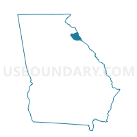
Outline

Summary
| Unique Area Identifier | 561380 |
| Name | 105196 - MOSS-RUCKERSVILLE Voting District |
| County | Elbert County |
| State | Georgia |
| Area (square miles) | 58.43 |
| Land Area (square miles) | 49.48 |
| Water Area (square miles) | 8.95 |
| % of Land Area | 84.68 |
| % of Water Area | 15.32 |
| Latitude of the Internal Point | 34.13698290 |
| Longtitude of the Internal Point | -82.75920790 |
Maps


Graphs
Select a template below for downloading or customizing gragh for 105196 - MOSS-RUCKERSVILLE Voting District, Elbert County, Georgia


Neighbors
Neighoring Voting District (by Name) Neighboring Voting District on the Map
- 105189 - ELBERTON Voting District, Elbert County, GA
- 105190 - LONGSTREET Voting District, Elbert County, GA
- 105192 - PETERSBURG Voting District, Elbert County, GA
- 105199 - GAINES Voting District, Elbert County, GA
- 105315 - CENTERVILLE Voting District, Elbert County, GA
- Calhoun Falls Voting District, Abbeville County, SC
- Lowndesville Voting District, Abbeville County, SC
Top 10 Neighboring County Subdivision (by Population) Neighboring County Subdivision on the Map
- Elberton CCD, Elbert County, GA (13,749)
- Antreville-Lowndesville CCD, Abbeville County, SC (3,130)
- Calhoun Falls CCD, Abbeville County, SC (3,064)
- Coldwater CCD, Elbert County, GA (2,890)
Top 10 Neighboring Unified School District (by Population) Neighboring Unified School District on the Map
Top 10 Neighboring State Legislative District Lower Chamber (by Population) Neighboring State Legislative District Lower Chamber on the Map
Top 10 Neighboring State Legislative District Upper Chamber (by Population) Neighboring State Legislative District Upper Chamber on the Map
Top 10 Neighboring 111th Congressional District (by Population) Neighboring 111th Congressional District on the Map
Top 10 Neighboring Census Tract (by Population) Neighboring Census Tract on the Map
- Census Tract 5, Elbert County, GA (5,849)
- Census Tract 4, Elbert County, GA (4,055)
- Census Tract 9503, Abbeville County, SC (3,130)
- Census Tract 9506, Abbeville County, SC (3,064)
- Census Tract 2, Elbert County, GA (2,890)